Lovell Gulch Loop
 |
 |
 |
 |
 |
 |
 |
 |
 |
 |
 |
 |
 |
Distance:
5 miles
Type:
Single Track/Double Track
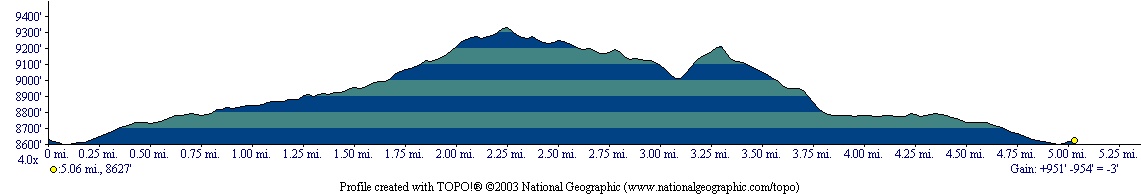
Vertical Gain:
900 ft
Difficulty:
Easy/Moderate
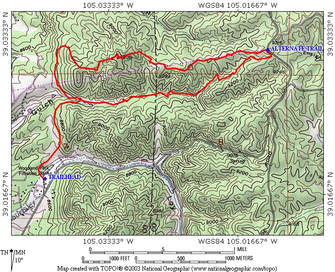
Topographical Map:
Elevation Profile:
Trailhead:
When entering Woodland Park from the East via Highway 24, turn right at the stoplight next to McDonalds. This is Baldwin Street, as you follow Baldwin Street North it will become Rampart Range Road. From the stoplight you will need to go 2 miles. Look for a small sign on the Left labeling the parking lot for Lovell Gulch. There is a Ranger station here with several garages. Don't block any of the garages when you park.
Summary:
The trail begins at the West end of the parking lot. Begin by heading West across a gully, once past the gully the trail will sharply turn North. Several paths connect along the way, but stay with the most obvious trail. After crossing a small ridge the trail will descend to a valley bottom and cross a small stream. Just after crossing the stream there will be a T-intersection with a sign. Take either direction to do the loop. I prefer going right East first as this way takes on the elevation gain at an easier rate. I will describe the loop in this direction (counter-clockwise) Again as you are hiking there will be several side paths and short-cuts, but stick with the most obvious path at the bottom of the valley along the creek. The elevation gain will be gradual, but constant. The trail will lead you through some nice rock formations and aspen groves. Once you reach the Eastern most point of the loop you have reached the highest point on the trail and the views start to open up. The trail will change to a double track trail that heads back West beneath some large powerlines. This is actually a service road for the powerlines, but it is closed to vehicles. The trail will descend for a while, before you reach the last uphill section. This section is steep, but short. Once you've reached a point where you will have a great view of Woodland Park, it's all downhill from there. The descent has a few steep sections that can be slippery, so take your time and watch your step. The trail turns back into a single track and leaves the power lines. You will pass near some fences which are the boundary of private property before reaching the T-intersection. Turn right at the intersection and head back to the trailhead.
|
Distance: |
5 miles
|
|
Type: |
Single Track/Double Track
|
|
Vertical Gain: |
900 ft
|
|
Difficulty: |
Easy/Moderate
|